BLM Hydraulic Fracturing Rule Expected September 2015

This past March the Federal Bureau of Land Management (BLM) released new rules on hydraulic fracturing activities on federally managed lands. The BLM oversees and performs regulatory duties on around 700 million subsurface acres of federal mineral estates and 56 million acres of Indian mineral estates. The new rule aimed to review and update regulations of oil and gas development on public and tribal lands first established in the 1980s. BLM studied current state/tribal regulations, consulted with environmental experts, and reviewed 1.5 million public comments. According to the BLM press release the key components of the rule include the following:

  • Provisions for ensuring the protection of groundwater supplies by requiring a validation of well integrity and strong cement barriers between the wellbore and water zones through which the wellbore passes
  • Increased transparency by requiring companies to publicly disclose chemicals used in hydraulic fracturing to the Bureau of Land Management through the website FracFocus, within 30 days of completing fracturing operations
  • Higher standards for interim storage of recovered waste fluids from hydraulic fracturing to mitigate risks to air, water and wildlife
  • Measures to lower the risk of cross-well contamination with chemicals and fluids used in the fracturing operation, by requiring companies to submit more detailed information on the geology, depth, and location of preexisting wells to afford the BLM an opportunity to better evaluate and manage unique site characteristics

Continue reading

Posted in Energy, Hydraulic fracturing, Industry news, Oil & gas | Comments Off on BLM Hydraulic Fracturing Rule Expected September 2015

How to map points from Excel in Google Earth Pro

Environmental professionals often use Google Earth as an inexpensive way to view and analyze data. In February, we wrote about the relaunch of Google Earth Pro as a FREE program available to anybody with a computer. One of the key advantages to using the professional version, is that Google Earth Pro can import huge tables and place your information on the globe. Did I mention that it was FREE?

In this post I will teach you how to take latitude and longitude data from within an excel table and turn it into a placemark within Google Earth Pro. In addition, I will teach you how to save your points as a KMZ file for use in Google Earth. Continue reading

Posted in Geomapping, GIS, Technology | Comments Off on How to map points from Excel in Google Earth Pro

USGS Study: Water Use in Fracking

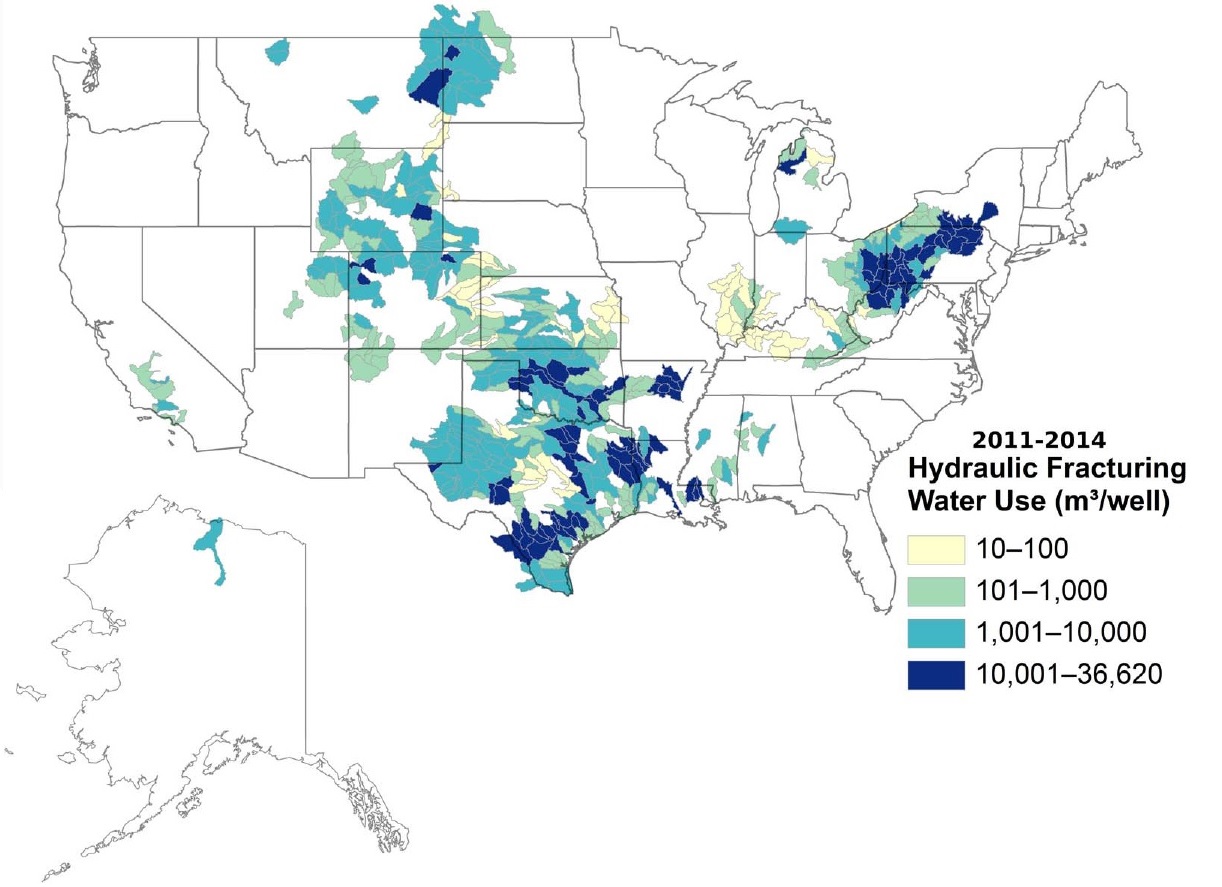
Water Used for FrackingOur city of Austin has seen a much wetter summer than many of us expected. That being said, drought and water use continue to be major issues across the country. The USGS recently released a study on water use in hydraulic fracturing, or “fracking,” across the US. The study was conducted in order to better understand where and to what extent water is being used in this industry. Continue reading

Posted in Energy, Geomapping, Groundwater, Hydraulic fracturing, Industry news, Oil & gas | Comments Off on USGS Study: Water Use in Fracking

Happy 4th of July!

Have a safe and happy Fourth of July! While you’re winding down the work week, check out a few of our recent tweets from our twitter feed.

Continue reading

Posted in Industry news | Comments Off on Happy 4th of July!

Vapor intrusion

This month the EPA released a final technical guide to aid environmental professionals in effective investigation and mitigation of vapor intrusion. The new technical guide, Assessing and Mitigating the Vapor Intrusion (VI) Pathway from Subsurface Vapor Sources to Indoor Air, recommends a framework for assessing VI and systems for monitoring and terminating building migration. Additionally, the EPA also released a technical guide for Addressing Petroleum Vapor Intrusion (PVI) At Leaking Underground Storage Tank Sites. This guide provides specific recommendations on addressing vapor intrusion releases of petroleum-based fuels and the technical information to support the recommended actions.

Vapor Intrusion is defined by the Environmental Protection Agency as “the migration of volatile organic chemicals (VOCs) from contaminated groundwater or soil into an overlying building.” If the vapors accumulate in the building they can potentially put human health at significant risk.

W&M Environmental recently held a webinar “Vapor Intrusion – It’s Not Just Hot Air.” An expert in environmental and geotechnical engineering projects in the Northeast and Southwest, Frank Clark, P.E., P.G., analyzed the issue of Vapor Intrusion.This webinar discusses important issues related to the investigation, evaluation, and mitigation of vapor intrusion. You can watch the webinar on YouTube.

Webinar Highlights

  • Chemicals of Concern/What chemicals to focus on
  • Mechanisms for Vapor Intrusion
  • Where vapors originate
  • Triggers of Vapor Intrusion study (RECs)
  • Evaluating VI Potential
  • Difficulties in evaluating
  • Sampling: groundwater, soil gas, & sub-slab soil gas & indoor air
  • Gradients vs. critical distances to search
  • Continue reading

    Posted in Environmental data, EPA | Comments Off on Vapor intrusion

    What is a Texas Municipal Settings Designation (MSD)?

    Texas MSD report

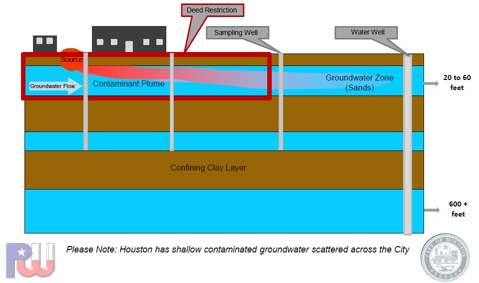
    Houston Public Works Department – MSD Contaminant Plume Diagram

    A Municipal Settings Designation, or MSD, is a voluntary regulation that prevents contaminated groundwater from being used beneath a specific property. This means that a property owner can voluntarily request a city ordinance to prohibit future use of the groundwater beneath a property from being used as a potable water source. Once a property obtains an MSD designation, the water beneath it is restricted from being used to drink, shower, bathe, cook, or irrigate food crops. Continue reading

    Posted in Environmental data, Groundwater, TCEQ, TX | Comments Off on What is a Texas Municipal Settings Designation (MSD)?