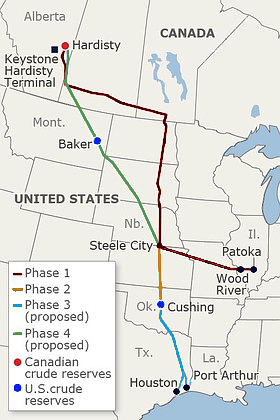
 Most everyone has heard about the proposed Keystone XL pipeline at this point. The international pipeline is proposed to deliver Canadian crude oil from northeastern Alberta to markets and refineries in the United States. The pipeline is already partially constructed but must be approved by the State Department before it can cross the US/Canada border. President Obama rejected the first application in 2012, citing concerns about the impact of the pipeline passing through the Sand Hills region of Nebraska. All of this found me asking, “What’s the big deal? There is a latticework of pipelines that crisscross the country. Why is everyone up in arms about this one?” Which led me to the much more important question: “Are pipeline leaks common enough to be such a big issue?” I was surprised to find the answer to this is a loud and resounding YES.
Continue reading
Keystone XL and pipeline leaks in the United States
Common abbreviations used by the TCEQ
When conducting state agency file research it’s important to know the lingo. Reports and correspondence documents found at the Central Registry are loaded with technical jargon and acronyms. This is a brief guide to the most common acronyms used by the Texas Commission on Environmental Quality (TCEQ).
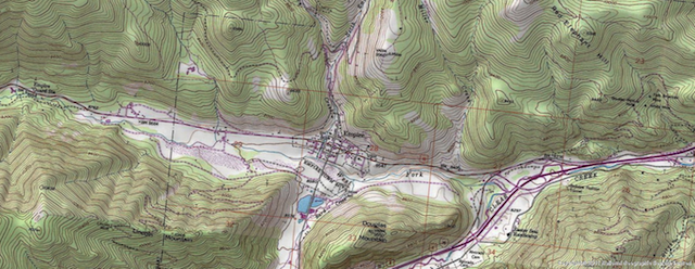
Zooming in on topographic maps
Topographic maps, also known as topo maps, typically display elevation characteristics, natural and structural features as well as hydrography and infrastructure data in a large-scale format. Essentially, topo maps provide a third dimension to an otherwise flat map. Topo maps are used for a range of applications, from geographic research studies to environmental impact assessments for commercial and residential development – and beyond. Understanding how to read the direction of slope and gauging the degree of elevation change can be valuable when analyzing recognized environmental conditions within the vicinity of your target property – potentially allowing you to determine where contaminants are likely to migrate.
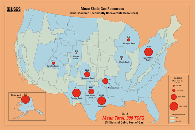
USGS Energy Resources Program establishes national data archive
In accordance with provisions stipulated by the Energy Policy Act of 2005, the USGS Energy Resources Program conducts research, compiles data, and provides information about energy resources in the United States. Provisions of the bill established the National Geological and Geophysical Data Preservation Program (NGGDPP) as a centralized national archive. The NGGDPP is tasked with collecting geoscience data that are scattered across various state agencies and private data collections.
Continue reading
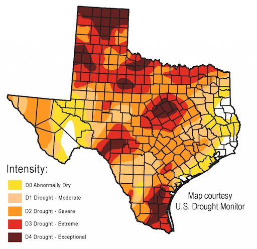
Texas lawmakers thirsty for water funding in 83rd Legislature
Water remains a high priority for the members of the Texas 83rd Legislature session. According to the Texas Water Development Board (TWDB), an alarming 96% of Texas is currently experiencing drought conditions, with the statewide water reservoir only 67% full – about 13% short of where it should be this time of year.
Love Canal disaster and the origin of CERCLA: Part 1
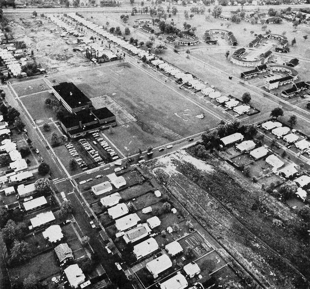
The Comprehensive Environmental Response Compensation and Liability Act – also known as CERCLA or Superfund – has changed the landscape of legal precedent and liability in cases of environmental contamination. It is the driving legislation behind Phase I site assessments required or elected during real estate transactions. In the 1970s, there were two cases that created a public outcry for the federal legislation that would become CERCLA: the Love Canal site in Niagara, New York and the Valley of Drums site near Louisville, Kentucky. Both sites exemplified the worst fears of potential fallout from cheap and negligent disposal of toxic waste. America had a lot of cleaning up to do after a very lucrative period of industrialization.
Continue reading

