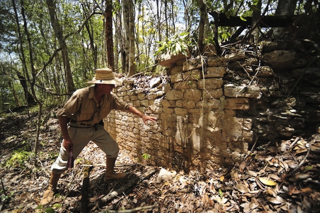
Stereoscopy imaging used to identify ancient Mayan ruins

Chactun MexicoImage source: Reuters

Ivan Sprajc and a team of archeologists from the National Institute of Anthropology and History (INAH) recently discovered ruins of a large Mayan city in southeastern Mexico. The 54-acre area is located in a remote jungle with dense vegetation that had previously only been penetrated by loggers and rubber tappers. Due to a history of limited accessibility in the area, the only feasible way to locate these ruins was by looking at aerial photos using stereoscopy. Continue reading

Posted in Aerial photography, Geomapping | Comments Off on Stereoscopy imaging used to identify ancient Mayan ruins

How to convert Google KMZ files and shapefiles into desired formats

In this post I will teach you how to convert a Google KMZ file into a shapefile. In addition, I will teach you how to convert an ArcGIS layer into a KMZ file for use in Google Earth.
Continue reading

Posted in Geomapping, GIS | Comments Off on How to convert Google KMZ files and shapefiles into desired formats

Gulf Coast Restoration Plan available for public comment


Photo Credit: Kris Krug via Compfight cc

In the wake of the Deepwater Horizon well blowout and oil spill of 2010, the Gulf Coast Ecosystem Restoration Council was established by the Resources and Ecosystem Sustainability, Tourism, Opportunities Revived Economies (RESTORE Act) to restore the Gulf Coast region’s ecosystem and economy. The Council recently released the first draft of the Initial Comprehensive Plan: Restoring the Gulf Coast’s Ecosystem and Economy and the Programmatic Environmental Assessment. The plans are listed on the Federal Register and are open for public comments until June 24, 2013.
Continue reading

Posted in Energy, EPA, Industry news, Oil & gas, Regulatory issues, Surface water | Comments Off on Gulf Coast Restoration Plan available for public comment

Slidedeck: Historical aerials of Austin’s evolving downtown

Austin’s new 737 area code debuted on June 1, underscoring the rapid growth that the Austin area has been experiencing for more than two decades. Regardless of how one quantifies the indicators of economic growth across wide-ranging and diverse sectors of industry, the advent of a second area code is a sure sign of an expanding economy and population growth. In recognition of this “achievement,” Environmental Prose thought it would be interesting to observe Austin’s growth from a different perspective – one viewed through the lens of historical aerial imagery in the form of a slideshow. Enjoy!

Mark Gamble
Program Manager – Aerials and Historical Mapping
mgamble@banksinfo.com

Posted in Aerial photography, Austin | Comments Off on Slidedeck: Historical aerials of Austin’s evolving downtown

Funding slashed for FEMA Hazard Mapping and Risk Analysis Program

Last August, we informed you that President Obama signed into law the Flood Insurance Reform Act, which introduced changes to the National Flood Insurance Program (NFIP). The legislation was implemented to improve efficiency of the program while equipping FEMA with resources needed to update the country’s flood maps. In addition, the Flood Insurance Reform Act introduced measures that would help the program become solvent, such as eliminating subsidized insurance rates for properties with repeated flood claims. According to FEMA, “Key provisions of the legislation will require the NFIP to raise rates to reflect true flood risk, make the program more financially stable, and change how Flood Insurance Rate Map (FIRM) updates impact policyholders. The changes will mean premium rate increases for some – but not all – policyholders over time.” With the 2013 fiscal budget constraints and recent sequester measures, it appears that FEMA will receive even less funding than in previous years. The slashed funding may ultimately set back the program 5 to 7 years and leave many Americans with outdated flood maps that do not represent the true level of risk. Continue reading

Posted in Analysis, Environmental data, Geomapping, Surface water | Comments Off on Funding slashed for FEMA Hazard Mapping and Risk Analysis Program

Revised BLM rules for fracking on federal and tribal lands

fracking regulationsThe Department of Interior’s (DOI) Bureau of Land Management (BLM) has released an updated draft of the proposed new rule governing fracking on federal and tribal lands: oil and gas, well stimulation, including hydraulic fracturing, on federal and Indian lands.

Current federal regulations on fracking were first established in the 1980s. Since then, new horizontal drilling technologies have been introduced, which has led to increased oil and gas extraction in parts of the country that previously did not produce significant amounts of oil or gas. In response to the increase in production, several states have revised their regulations of hydraulic fracturing. And with public interest in fracking growing considerably since the first rules were established, the DOI has also decided to review and update current laws. The latest draft of the DOI revisions (pdf) was released last week and is open for public comment for 30 days.
Continue reading

Posted in Energy, Environmental data, Groundwater, Hydraulic fracturing, Industry news, Regulatory issues | Comments Off on Revised BLM rules for fracking on federal and tribal lands