Aerial photography is one of the best tools anyone, especially environmental professionals, can use to determine land use changes over time. In some cases, viewing aerial photographs can be the only way to identify the history of a site. For example, a former gas station that was removed to make way for a new commercial building may not be easily discovered in a regulatory database search. Viewing historical aerials over decades may reveal former land uses that could impact an environmental site assessment.
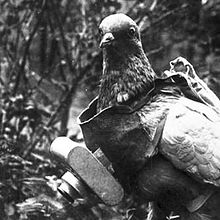
According to the PAPA History of Aerial Photography , aerial photography can be traced back to the mid-19th century when Gasper Felix Tournachon took a photo of Paris from a hot air balloon. During the remainder of that century, a number of different methods – including kites, pigeons strapped with cameras, and rockets – were used to capture photos of cities from above. In 1909, the first aerial photograph was taken from an airplane. Airplane aerial photography became more widely used during World War I and was a tremendous improvement over battle maps that were drawn by hand.
In the United States, Sherman Fairchild, an innovator of commercial aerial photography, developed new camera and airplane technology in the 1930s. Most of the country was captured by airplane aerial photography for the first time over the next decade by Fairchild Aircraft and other commercial companies that were contracted by the United States Department of Agriculture (USDA) and United States Geological Survey (USGS). During the 1960s new uses for aerial photography were introduced in a variety of industries, and new technologies emerged like oblique and color-infrared imagery. In the 1980s, USGS launched the National High Altitude Program, in which the entire country was aerially photographed from 1980 to 1989. In 1987, USGS began the National Aerial Photography Program (NAPP), which set out to collect photographs over the next decade for the contiguous 48 states. The National Agriculture Imagery Program (NAIP) was launched in 2003 by the USDA and began taking aerial photographs for each state at least once every 5 years. In 2009, the program was revised to a 3-year cycle.
In addition to government-sponsored programs, there are many individuals and private companies that can provide aerial photography for a single site, a large ranch, or an entire city. There are now numerous sources and repositories that house historical aerial photography collections including federal, state, and local agencies as well as commercial companies.
The Professional Aerial Photographers Association (PAPA) has posted an article that recaps the history of aerial photography with fascinating examples of early images that still remain. Visit the PAPA website.
 Until next time,
Adam Marshall
Program Manager – Aerials & Historic Mapping
amarshall@banksinfo.com
